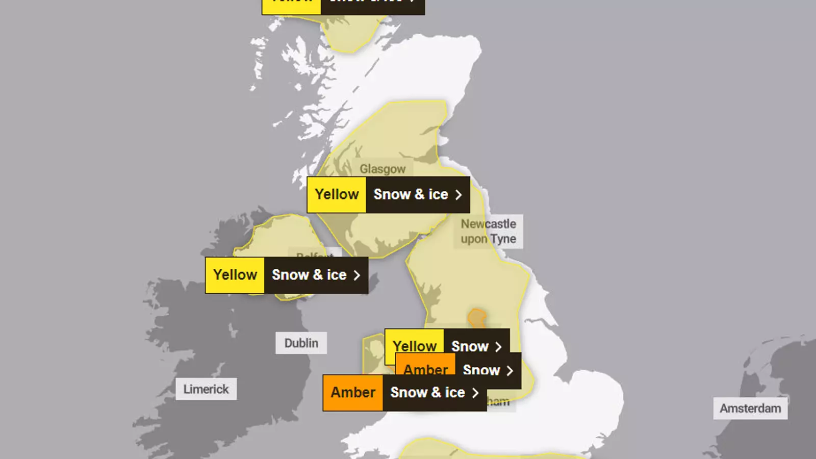
The Met Office weather forecast predicts that parts of England and Wales will experience up to 25cm of snowfall on Thursday. This has led to the issuance of two amber weather warnings for snow and ice, as well as five yellow weather warnings for rain, snow, and ice across the UK. While the amber alerts primarily cover regions in England and Wales, the yellow warnings extend to most of England, Wales, and Northern Ireland.
When an amber warning is in effect, there is a “good chance” that rural communities may become temporarily cut off. Travel delays and road blockages are also likely, thereby stranding vehicles in affected areas. To make matters worse, power cuts are possible, and mobile phone coverage may be affected. Rail travel disruptions and cancellations are expected, whereas untreated pavements and cycle paths will become impassable.
The amber warning for snow encompasses the Peak District and South Pennines, running from 12pm to 6pm on Thursday. In these areas, high ground above 300m could see up to 25cm of snow accumulation. Derbyshire, Staffordshire, South Yorkshire, and West Yorkshire are the specific regions that will be affected by this warning. The Met Office also issued a separate amber warning for snow and ice from 8am to 3pm on Thursday, covering parts of North Wales and Northwest Shropshire. These areas, situated above 200m, are expected to receive 20-25cm of snow. The introduction of milder air from the South may cause the snow to turn into freezing rain on higher routes above 200m.
According to Met Office meteorologist Amy Bokota, places “inland and higher up” are likely to experience the most significant snowfall due to the easterly winds. Although it is “unlikely” that substantial snow cover will persist for several days, hazardous driving conditions are expected on Thursday, particularly during the afternoon and early evening. Fortunately, the forecast indicates that most locations will see a return to milder conditions by the end of Thursday.
Several regions in the UK are under yellow snow and ice warnings, which are in place until 6am on Friday. These areas include the East Midlands, North East England, North West England, Wales, West Midlands, Yorkshire and Humber, and Northern Ireland. Additionally, certain parts of Scotland, namely Central, Tayside and Fife, SW Scotland, Lothian Borders, and Strathclyde, will have yellow warnings from 6pm on Thursday until 3pm on Friday.
While some regions will be spared from snowfall, the Met Office warns of possible rainfall until 6am on Friday. This yellow rain warning implies that a few homes and businesses in affected areas could experience flooding. Consequently, travel by bus and train may be disrupted, leading to longer journey times. Motorists should also be cautious of spray and flooding on roads.
The upcoming snowstorm poses significant challenges across different parts of the UK. With the potential for substantial snowfall, travel disruptions, power cuts, and a risk of flooding, it is crucial for individuals in affected areas to exercise caution and stay updated on the latest weather advisories.
Leave a Reply